
It’s an odd practice, the commemorative naming of streets. Those who have influence over the naming of streets, the wealthy and powerful, are the most commonly commemorated. 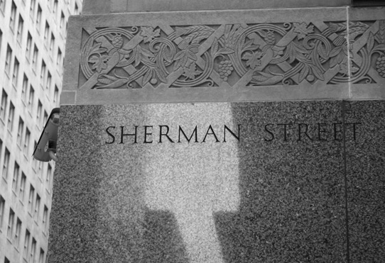 Every American city seems to have a set of streets, usually near its center, named after the first ten (or so) presidents as well as other Federal founding fathers. It is argued that this practice originated with James Thompson’s original plat of Chicago.1 Some of these streets include Franklin, Washington, Jefferson, Adams, and Madison. Then are the names of early local notables and early residents, plenty of which are in and around the Loop; Beaubien, Kinzie, Hubbard, Clinton, and Clark. Local politicians are widely commemorated, like mayors Ogden, Wentworth, Rumsey, Medill, Rice, Creiger, Heath, and Cermak. And of course, there are the countless streets named after the merchant princes, robber barons, real estate speculators, land developers – and their daughters.
The other ways in which streets acquire names which are relatively free from political meddling. The organic, utilitarian practice of naming streets for their function, geography, or destination are conventions as old as streets themselves. North Water, South Water, and Ridge Road are examples of streets as geographical descriptions. Streets like Milwaukee and Vincennes, which are named for their destination, are quite uncommon in Chicago, especially in comparison to Boston or New York City.
Lastly, there is the severely rational approach, where the street is numbered or lettered. This is the result of top-down planning where the street grid is platted at an early stage of, or prior to development. Edward Brennan, the man who implemented Chicago’s current street numbering system, advocated this approach to naming. His ideas are manifest in the Alphabet Avenues of the East Side, as well as K-Town and the O-Zone to the west. East of the Calumet River between 95th and 117th streets, both lettering and numbering overlap. The east-west streets are numbered and the north-south streets are lettered (Avenues A through O), resulting in Manhattan-like intersections. Meet me at 114th Street and Avenue O, for example.
When streets are renamed or built over, the old names are forgotten along with their namesakes. However, it is inevitable that sometime in the not-too-distant future, some curious individuals will come along and mine the esoteric depths of collective memory. Here we’ve listed every street in the area bordered by Roosevelt, Jefferson, Grand, and Lake Michigan that has disappeared.
| Name
|
Location
|
Last Seen2
|
What is there now
|
| Bunker Street | 900S, 400W-800W | 1928 | One segment remains between Jefferson and Clinton as Grenshaw Street. |
| Central Avenue | — | 1892 | Renamed Beaubien Place after the famous pioneer innkeeper. |
| Charles Street | 400W, 400S-600S | 1892 | Not to be confused with Charles Place (Lomax), this street was entirely replaced with lead-in trackage for Union Station. |
| Dock Street | — | 1897 | A very small street at the intersection of what is now Wacker and Wabash. Presumably, it led to a dock or two. |
| Dunn Street | — | 1910 | A small street in the Cook Court area, see the entry on Cook Court. |
| Eldredge Court | 900S, 0E-100E | 1921 | Renamed 9th Street, in the 1910s, similarly to Hubbard Court, Peck, and Harmon. |
| Ellsworth Street | 350W 700S-830S | 1913 | Once an access road for the Polk Street viaduct, most of this area is currently occupied by a Postal Service warehouse. A road does remain where Ellsworth once was, however, it is on Federal property and it is unlikely that it is still signed as such. |
| Fifth Avenue | 200W | 1916 | Wells Street was renamed Fifth Avenue in 1870 to remove negative associations with the name, but was reverted to Wells in 1916. Not to be confused with the Fifth Avenue on the west side, formerly Colorado Avenue. Both Fifths were named after the famous New York avenue in failed efforts to covey prestige. |


Right: Robinson’s Map of Chicago, Encyclopedia of Chicago, 1886.
| Forquer Street | 900S, 400W-930W | 1937 | One segment, most of which is on the property of a ComEd substation, remains in the central area, between Jefferson and Clinton. The street was renamed Arthington in the late 1930s. |
| Gilpin Place | 830S, 350W-900W | 1928 | Segments still exist between Canal and Desplaines as Cabrini Street. It has alternatively been found on maps as Ewing Street. Similarly to Forquer/Arthington, most of what remains is private, belonging to a ComEd substation. |
| Harmon Court | 1100S, 0E-100E | 1921 | Renamed 11th Street in the 1910s, similarly to Hubbard Court, Eldredge, and Peck. |
| Hubbard Court | 700S, 0E-400E | 1921 | Not to be confused with Hubbard Street (which Hubbard Court predates), this was renamed to 7th Street sometime between 1921 and 1928. It was again renamed in 1934 after the Italian aviator Italo Balbo. The South Loop Club, built during 7th Street’s short existence, still has its original sign: 7th Street Hotel. |
| Hydraulic Place | 150S, 200W-0W | 1910 | Best street name ever, too bad that it was renamed Marble Place. |

Chicago Tribune, 1939
| Indiana Avenue | 500W-600E | 1911 | Grand Avenue’s former name east of the river. The entire street became Grand in 1911 as part of the Brennan plan. This broke the lakes n’ states naming convention of streets between Superior and Hubbard (formerly Michigan). |
| Law Avenue | 620W, 500S-800S | 1910 | A named alley, it has long since been built over. Since then, Chicago has been without Law (Avenue). |
| Lomax Place | 550S, 200W-300W | 1946 | This small street was replaced by an interchange connecting the Congress Expressway and Wacker Drive. Before 1910 or so, it was known as Charles Place. This is the same interchange in which Oscar D’Angelo “park” is situated. |
| Market Street | 350W, 200N-500S | 1949 | Reconstructed as the western extension of Wacker Drive beginning in 1949. |
| Mather Street | 740S, 350W-400W, 500W-600W, 630W-800W | 1921 | Same story as Sebor, except the remaining portion is now Lexington Street. |


Right: DN-0009263, Chicago Daily News negatives collection, Chicago Historical Society.
| Michigan Street | 430N | 1910 | Renamed Hubbard Street. A reminder of this, one of many pre-Brennan Michigans, can be seen on a building at Hubbard/Wells. |
| Pacific Street | 130W, 300S-1000S | 1892 | The southern leg of LaSalle Street, which is now cut off in two different places. |
| Peck Court | 800S, 0E-100E | 1921 | Renamed to 8th Street in the 1910s, similarly to Hubbard Court, Eldredge, and Harmon. |
| River Street | 50E, 230N-330N & 330N, 100E-200E | 1910 | Became part of Wacker Drive in 1926. |
| School Place | 50S, 500W-800W | 1910 | Presidental Towers now occupies the site, though the street had long since disappeared. It’s not clear which if any school it was named for. |
| Sebor Street | 700S, 350W-400W, 540W-600W, 630W-800W | 1921 | Segments were removed for rail, and later the Dan Ryan expressway. One section between Jefferson and Clinton still exists as Vernon Park Place. |
Left: DN-0008826, Chicago Daily News negatives collection, Chicago Historical Society. Right: Man_of Steel
| South Water Street | 230N, 100E – 350W | 1921 | Though a bit of it remains east of Michigan Avenue under Illinois Center, the majority of the street was reconstructed as Wacker Drive in 1926. |
| Stewart Avenue | 400W, 600S-2300S | 1910 | Although it still exists south of Archer, Stewart used to continue north to Harrison before it was replaced with a mass of lead-in trackage for Union Station. Before 1910, a section was known as Beach Street. |
| Stowell Street | 1100S, 100W-180W | 1910 | Continuing west, many a street has occupied the position between Taylor and Roosevelt; Stowell, Harmon, DeKoven, Bunker, Belknap, 11th Street, Edgemont, Elburn, Seldon, Yeaton, Ashland Street, and of course, Grenshaw and Fillmore. Most of these have been renamed Grenshaw or Fillmore, some have been built over. Stowell’s fate is the latter, it was first removed for rail. The site is now occupied by a Target and one of those South Loop commodity condo towers. |
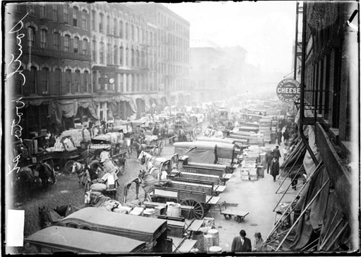
| Cook Court | 420N, 540-570W | 1972 | Before Kinzie Park (a private townhouse development) was built on this site at an as-yet-undetermined date, this area used to be a wasteland of sorts. Bounded by Grand Avenue, Kinzie Street, Metra tracks, and the river, at least two companies occupied the site. It is not clear what they were (see photo, above). Cook Court was a small street that serviced these businesses. The two streets in the new development are Clinton Street and Canal Street, however, Cook Court, which would have bisected them, is not included. Although there is a very small street that does connect Clinton and Canal, it is not signed. For some reason, this street does not show up consistently on historical maps. |
| Sherman Avenue | 156W, 300-1000S | 1972 | Renamed Financial Place, most likely in 1981-82 when LaSalle street station was demolished and a new station was built under the new Stock Exchange building. The new name reflects the long-standing activity in the area, Chicago’s equivalent to Wall Street. |
2 The dates included under the “Last Seen” column are not definitive. These dates reflect the latest mention of the street that we can find using numerous sources.


