
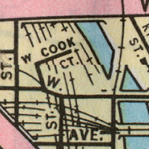
In order to begin this, our first “street necrology” page for this site, we needed a physical constraint. The current boundaries of the 312 area code were chosen as an arbitrary border because it is a large but workable size, and comprises the center of the city. This area is bounded by Armitage to the north, Ashland to the west, and 31st to the south. The map used for this section is AAA’s 1972 Chicago map, which is located in the Maps section. Even though the map was published in 1972, it does not necessarily mean that it is a representation of what existed during that year. For example, the Damen Avenue viaduct is not shown on this map, even though it was built in the 1950s.
There are two different ways a street qualifies for this page. 1) A unique, once occurring street that physically no longer exists. An example is Bauwans Place. 2) A street which still physically exists, but has been renamed, reconfigured, or built over, an example of which is Seneca Street, now called Mies Van der Rohe Drive for one section and New Street for another.We have attempted to include every street on the 1972 map that qualifies, except for Grove Street and Ogden Avenue, which have their own pages. I am certain at least a street or two was missed, so if you spot one, let us know. Keep the constraints in mind, however.
Another point to note: the 312 area code was one of the orignal codes when the system debuted in 1951. It applied to the entire city of Chicago and did so until 1996, when 773 was introduced. 312’s boundaries, as of 2007, the ones used for this page, are; Armitage to the north, Western to the west, and 35th to the south. In short, 312 was different in 1972, but disregard that as this section is not a history of telephony. Its an arbitrary time warp – 312 now, streets then. For more about telephone numbers, see this page.
Lastly, we suggest you follow along on the map, as this may get confusing (esoteric). Here goes.| Name | Location | What is there now |
| West 11th Street | 1100S, 1000-1132W | Along with a portion of Blue Island Avenue, this street was removed to allow for the expansion of St. Ignatius high school. There are also some new houses built over it, as well as service buildings for UIC. May Street breaks into double cul-de-sacs where the intersection would have been, but is peculiarly gated off. 11th Street only runs for another block anywhere in the city, between Michigan and State streets. |
| Almond Street | 2121W, 900-1000S. | The School of Public Health West building, part of UIC’s medical campus. |
| Barber Place | 1430S, 540-800W | East of the Dan Ryan expressway, this street was built over by UPS. To the west it was first paved over as a parking lot, but more recently developed as part of University Village. |
|
|
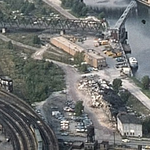
Right: The Cook court area circa 1975.
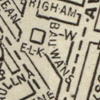
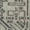
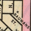
| Bauwans Street | approx. 1330N, 1600-1650W. | As evinced by the three images, above left, this area has gone through frequent re-namings and reconfigurations. On the first image, Bauwans cuts north while a small street named Elk connects it and Milwaukee ave. In the middle image, Elk has been renamed to Evergreen to improve continuity. In the last image, Evergreen connects to Paulina instead of Milwaukee, and Bauwans’ northern portion has been renamed as Marshfield, again for continuity. Currently, the area is a parking lot for a strip mall including a Kmart and a Jewel. Bauwans’ path is still defined by the older buildings in the south portion of the lot. Curiously, the #9 Ashland southbound bus stop at the former street is still referred to as Bauwans. |
| Cook Court | 420N, 540-570W. | Before Kinzie Park (a private townhouse development) was built on this site at an as-yet-undetermined date, this area used to be a wasteland of sorts. Bounded by Grand Avenue, Kinzie Street, Metra tracks, and the river, at least two companies occupied the site. It is not clear what they were (see photo, above). Cook Court was a small street that serviced these businesses. The two streets in the new development are Clinton Street and Canal Street, however, Cook Court, which would have bisected them, is not included. Although there is a very small street that does connect Clinton and Canal, it is not signed. For some reason, this street does not show up consistently on historical maps.
This area, though not necessarily Cook Court, can be seen in the beginning of the 1975 John Wayne vehicle Brannigan. The area is also the location of Mom’s HQ in the awful 1983 “film” Doctor Detroit, starring Jake Blues himself. |
Right: Bowler Street (formerly DeKalb Avenue) with section cut off to traffic and the former Boone Street to the right.
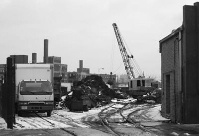
| Crooked Street | approx. 1950N, 1300-1400W. | The A.Finkl steel company has occupied this site since 1902. Crooked Street was (and still is) an access road for the plant. It may have been signed and public in the past, but is no longer. There is a rail spur along most of it, in addition to heaps of scrap metal. As Finkl does not plan on remaining much longer at this location, Crooked Street will fade further into oblivion when the plant is torn down for luxury condos, unless they name them Crooked Courts. |
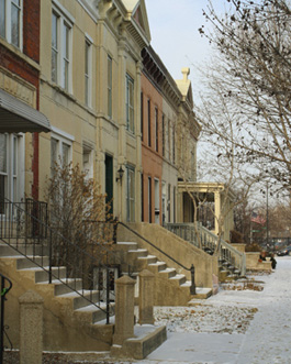
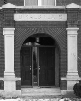
| De Kalb Avenue | 2010W at 700S to 2200W at 940S. | Running parallel with Ogden Avenue for its short duration, this street has been shortened and renamed. The section from Polk Street to Flournoy Street was removed for a parking lot. The section on the other end from Boone to Leavitt was turned into a sidewalk. The remainder of the street was merged with Boone and renamed Bowler Street. Bowler is home to some of the finest and most unique rowhouses in the area. A similar street running parallel with Ogden and DeKalb, east of Ogden was called Kendall street. Also, there used to be a DeKalb Square, possibly near its original terminus at Flournoy. |
Right: Illinois Historic Preservation Agency
Right: Charles Cushman, Indiana University Archives, 1949.
| Garibaldi Place | 1526W, 800-1000S. | The Medical District City apartments, a private development, was built over this street and surrounding area in 1974. A small portion of the street remains unsigned as an alley and a small parking lot for a White Hen. The park located where the street would have intersected with Polk was renamed from McLaren Municipal Playground to Garibaldi Park. |
| Huguelot Court | 124E, 900-950N. | This one is a mystery. The only map it shows up on is this one. In others it is non-existant, and on very detailed maps it appears un-named. Odd. The only other place we’ve seen it is a 1912 street guide where it is called ‘Huguelet Place’. It has a twin just west of where it would be, Ernst court, which very much exists. |
| Jessie Court | 2050W, 400-420N. | An equally small bit of Seeley avenue ran parallel with this court, both of them were located on the property of what is now a pallet company. It was probably similar to Oswego street, a small street west of Ashland. |
Left: City of Chicago.
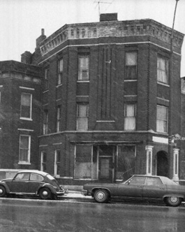
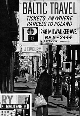
| Mautene Court | 1650W, 1244-1254N. | We found a photograph of Milwaukee avenue (above left) on a city-published newsletter that shows a street sign for this former street. It was taken in 1974, proving wrong our theory that Mautene hadn’t seen vehicular traffic during that era. The curb clearly identifies it as an actual street. Until recently, the site was occupied by a McDonalds with an adjacent plaza. It follows that the street was converted into a plaza sometime after 1974. Urban renewal? The plaza attracted bums in droves, and was torn down at some point in 2006. The plaza remains (though very cut up) but is inaccessible from Milwaukee avenue. |
| Quarry Street | 1100W, 2500-2632W | Named for nearby Stearn’s Quarry, this street was merged with Senour street. |
| Salt Street | 2500S at 1000W to 2550S at 950W | Renamed Corbett street after James Corbett, an engineer who founded a construction company specializing in sewers. It is now an access road for a boatyard. |
| Seneca Street | 236E, 500-540N, 800-920N. | The southern section of this street has been elevated and incorporated into Cityfront Plaza drive at the foot of NBC Tower, built in 1991. The northern section was renamed Mies Van der Rohe Way, probably somewhere between 1990 (post-modern?), when the Museum of Contemporary Art acquired the site of the former First Cavalry Illinois National Guard Armory and 1994, when the MCA completed their overhaul of the site. |
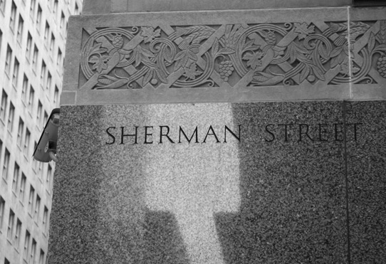
| Sherman Avenue | 156W, 300-1000S | Renamed Financial Place, most likely in 1981-82 when LaSalle street station was demolished and a new station was built under the new Stock Exchange building. The new name reflects the long-standing activity in the area, Chicago’s equivalent to Wall Street. |
| Todd Street | 500W, 2042-2060W | The parking lot for Lawrence’s Fisheries incorporates this former street. |
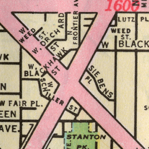

The area surrounding the intersection of Ogden and Clybourn has changed quite a bit since 1972. Every street within the boundaries of North, Halsted, Evergreen, and Larrabee are gone, with the exception of Ogden and Clybourn. Unlike Blackhawk and Schiller, for example, four of these streets, Fair, Frontier, Lutz, and Siebens, only existed here, and were entirely demolished during the 1970s and 80s.
This part of Ogden, in its current state, is merely a remnant. South of Clybourn it is a parking lot for the Sojourner Truth Parent Child center, but otherwise goes nowhere. North of Clybourn, there are townhouses built in the western half of the street, what remains is very little, barely the width of a car. Siebens Place refers to the Michael Sieben brewery, located at 1454-1478 N. Larrabee, which went out of business in 1967.


All Our Lives
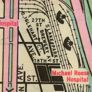
Brewery avenue refers to two breweries that called this area home. The Conrad Seipp brewery was at the north end of the street, and the Michael Keeley brewery, seen at left, was at the other. However, both the Seipp and Keeley breweries were closed long before this map was made. This entire area was one of the first areas of large-scale slum clearance urban renewal efforts by the city. Instead of moving out of the area, local institutions Illinois Institute of Technology and Michael Reese Hospital decided to stay. They worked in conjunction with the city and private companies to build the Lake Meadows and Prairie Shores high rise complexes. These mostly-middle class high rises were a successful example compared to other failed efforts at Corbusier style high-rises-in-a-park, most notably the Robert Taylor homes. Michael Keeley brewery closed in 1955, when the demolition of this entire area began. The fact that these streets still remain on a map in 1972 is an inaccuracy, the layout then would have been the same as it is today.
- Long Lost Loop Lanes
- Disconnected Yellow Signs
- Lake Shore Drive Redux
- Chaddick Institute Promoted Tour: The Exention and Removal of Ogden Avenue on Sunday, August 13, 2023
- Public Bath Houses


