Questions and Answers (Q&A) Forgotten Chicago Forum
Have a question about a specific element in Chicago's history? Ask Away!
Bryn Mawr Ave.
Posted by:
MIKETOUHY
()
Date: February 07, 2011 08:27PM
I assume prior to the 50's Bryn Mawr didn't end at East River Rd like it does today.
If so how far did it go?
I suppose Harlem Ave or could it have been Canfield?
Main reason I ask is because Bryn Mawr from Canfield to E. River RD. is not exactly parralel to Bryn Mawr East of that point.
If so how far did it go?
I suppose Harlem Ave or could it have been Canfield?
Main reason I ask is because Bryn Mawr from Canfield to E. River RD. is not exactly parralel to Bryn Mawr East of that point.
Re: Bryn Mawr Ave.
Posted by:
tomcat630
()
Date: February 09, 2011 04:15AM
On the Historic Aerials site, and older maps, Bryn Mawr goes out to Orchard Place airport, past old Manhiem Rd. Ended near where the new control tower and north runway are set.
Re: Bryn Mawr Ave.
Posted by:
MIKETOUHY
()
Date: February 09, 2011 07:05PM
That's funny.
While it does pick up in Rosemont, Im suprised it went that far considering in ends by a forest preserve and why would they have closed it off in the first place?
While it does pick up in Rosemont, Im suprised it went that far considering in ends by a forest preserve and why would they have closed it off in the first place?
Re: Bryn Mawr Ave.
Posted by:
tomcat630
()
Date: February 13, 2011 05:26AM
[url=http://forgottenchicago.com/maps/38/north_top_lg.jpg]1938 Map, North side,[/url]
Here is link to a 1938 map within FC, shows Bryn Mawr going through the Forest Preserve past East River to Mannhiem, etc.
Maybe was removed when I-294 was built? There was a grid of streets the Tollway displaced between Lawrence and Bryn, also. Historic Aerials would show what was really there.
Here is link to a 1938 map within FC, shows Bryn Mawr going through the Forest Preserve past East River to Mannhiem, etc.
Maybe was removed when I-294 was built? There was a grid of streets the Tollway displaced between Lawrence and Bryn, also. Historic Aerials would show what was really there.
Re: Bryn Mawr Ave.
Posted by:
MIKETOUHY
()
Date: February 13, 2011 08:02PM
Can't have anything to do with the Expreesway being built because it runs a streight line between Canfield and Manhheim.
Re: Bryn Mawr Ave.
Posted by:
tomcat630
()
Date: February 17, 2011 03:06AM
I meant the Tri-State Tollway, it cut across BM Ave, and the big interchange with 90 and 190 is huge. So, that and the airport covered over the extension of BM.
Re: Bryn Mawr Ave.
Posted by:
MIKETOUHY
()
Date: February 17, 2011 08:51PM
You don't seem to get what I'm saying.
Bryn Mawr today ends at E. River Rd. Which is the end of the city limits and the forest preserve is.
So how could it have anything to do with the Tri-State being built?
Bryn Mawr today ends at E. River Rd. Which is the end of the city limits and the forest preserve is.
So how could it have anything to do with the Tri-State being built?
Re: Bryn Mawr Ave.
Posted by:
tomcat630
()
Date: February 19, 2011 07:56AM
how could it?
The tollway took the land that Bryn Mawr was on past River Rd. I assume the Forest Preserves took the stub? Or, maybe the bridge over the DesPlaines rier was so old they didnt bother replacing it? Maybe historians may know for sure.
Lawrence Ave used to connect to Thorndale Ave on other side of O'Hare's footprint, btw.
I always thought the city grid should have been extended more into DuPage/NW Cook, too.
Re: Bryn Mawr Ave.
Posted by:
SmoothRT
()
Date: February 19, 2011 06:36PM
I used to work on Bryn Mawr just west of Cumberland. I once attended a convention in Rosemont, and then thought I would walk back to the office down Bryn Mawr. Well I hit the forest preserve, got incredibly muddy, and failed to cross the Des Plaines River. There is no evidence left of Bryn Mawr going through the forest preserve and connecting the Chicago and Rosemont portions of the avenue. Just lots of mud, trees and brush.
Re: Bryn Mawr Ave.
Posted by:
Rustymuscle
()
Date: February 19, 2011 11:16PM
SmoothRT Wrote:
-------------------------------------------------------
>There is no evidence
> left of Bryn Mawr going through the forest
> preserve and connecting the Chicago and Rosemont
> portions of the avenue.
Where Bryn Mawr used to traverse is now a trail in the forest preserve. Perhaps forest preserve expansion or the North West expressway was a reason it was closed down there?
Edited 2 time(s). Last edit at 02/20/2011 02:14AM by Rustymuscle.
Re: Bryn Mawr Ave.
Posted by:
Mikey
()
Date: October 16, 2013 01:40AM
I realize that I'm a bit late in this response, but I just learned of this forum yesterday.
Anyhoo, I was intrigued by this question, so I searched my extensive collection of Chicago maps and street guides, and came up with some info about Bryn Mawr ave.
According to my 1946 "Rand McNally (RM) Chicago Pocket Map", BM was continuous from Elston ave. to Mannheim/LaGrange rd. A 1946 Chicago area map showed BM to be the southern border of what was Orchard Field, continuing west to a block or so east of Mt. Prospect rd., which was 12000 west and is the county line.
My RM 1950 street guide shows BM ending at 7900 west, or Canfield. I believe that the city had not yet incorporated that huge hunk of land west of Canfield between Park Ridge (Higgins) and Irving Park rd.
A 1960 RM map shows BM ending at Cumberland but then continuing on from Des Plaines River Road to the eastern edge of O'Hare (a railroad track was the border at that point); in order to get to the edge of O'Hare, it went UNDER the tollway. At least that's what the map shows; it must have had to do that, since there was no other way for BM to get to the west side of the tollway.
Anyhoo, that's my 2 cents' worth.
Re: Bryn Mawr Ave.
Posted by:
Mr Downtown
()
Date: October 17, 2013 02:49PM
Unfortunately, RM maps of that era showed what streets where [i]dedicated[/i], not what streets [i]actually existed.[/i] For confirmation, look at all the streets they show between Lake Calumet and Torrence—none of which have ever existed on the ground. Aerial photos, or the topo maps made from aerial photos, are the only reliable sources for questions of this type.
Re: Bryn Mawr Ave.
Posted by:
tomcat630
()
Date: October 17, 2013 09:50PM
Bryn Mawr pops up again in Itasca and Schaumburg, in industrial or older residential areas. Along with Ardmore, Hollywood, and Devon. Thorndale is most commonly known continuation street up that way.
Re: Bryn Mawr Ave.
Posted by:
Mikey
()
Date: October 18, 2013 04:40PM
I agree with you, Mr. D. I've noticed this occurrence on a number of maps, but I didn't think this was the case with Bryn Mawr. The thing about those blocks of streets down around 134th and Stony have intrigued me since I first learned the Chicago street system, about 50-odd years ago. I would travel down through that area with my dad and wonder where the streets were. I guess the map companies jumped the gun.
Tomcat: Lawrence avenue is the same way. It starts and stops many times during its way west, and appears to end about 2 miles west of Stratford Square mall.
Mikey
Tomcat: Lawrence avenue is the same way. It starts and stops many times during its way west, and appears to end about 2 miles west of Stratford Square mall.
Mikey
Re: Bryn Mawr Ave.
Posted by:
tomcat630
()
Date: October 20, 2013 08:24AM
My hobby since I was a kid is finding Chicago grid streets out in the boonies. Most of the areas in collar counties are based on State/Madison, even DeKalb Co.
Re: Bryn Mawr Ave.
Posted by:
davey7
()
Date: October 21, 2013 06:56PM
Indianapolis is the same way - their street numbering goes several counties north of the city (not the addresses necessarily, but the street naming).
Re: Bryn Mawr Ave.
Posted by:
thimmaker
()
Date: April 29, 2015 08:37PM
A good example of maps jumping the gun is the Elgin/O'hare expressway which was shown on the maps for many years connecting Irving Park to Thorndale, but the airport cancelled that out.
Re: Bryn Mawr Ave.
Posted by:
Dunning1
()
Date: April 30, 2015 12:13PM
I work out on the far end of Bryn Mawr Avenue. Bryn Mawr runs west from the Des Plaines River, along side the Rosemont Expo Center, crosses River Road, and ends at I-294. On the other side of I-294, it again starts up by the baseball stadium and the Customs office, ending at the CN railroad tracks. The street west of I-294 is called Jennie Finch Way after a hero of the softball team using the stadium. I believe the Chicago Forestry Department and the Metropolitan Water Reclamation Department also had addresses on Bryn Mawr between the CN Tracks and Mannheim Road, but they were accessed off of a service road connected to Balmoral Avenue as it looped to meet Mannheim Road. There is currently a lot of construction right there, and a full interchange of Mannheim and Balmoral is being built, so its unclear right now how these facilities will be accessed.
Re: Bryn Mawr Ave.
Posted by:
tomcat630
()
Date: May 01, 2015 03:16AM
I think the original poster was wondering if there was once a bridge over the DP River for Bryn Mawr? Me too.
Re: Bryn Mawr Ave.
Posted by:
Mornac
()
Date: May 02, 2015 12:58AM
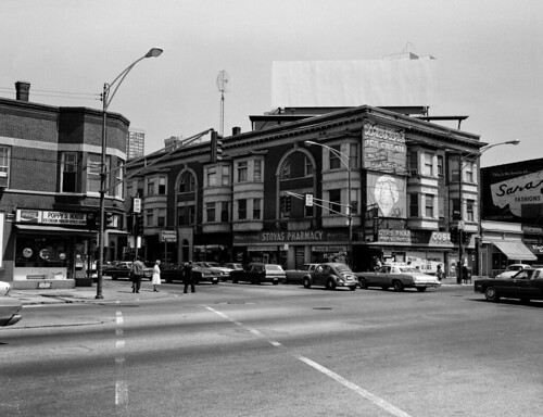
Not to get too far off topic here, but being from Edgewater, I'm more familiar with the east extremity of Bryn Mawr. Edgewater Beach Apts., A-B CTA station, Bryn Mawr Theater (admission was still 60 cents through the 1970's), Hellas Gyros (still there, still the best), and Stoyas Pharmacy.
Here's a photo circa 1970 looking east across Broadway:

Here's a photo circa 1970 looking east across Broadway:
Re: Bryn Mawr Ave.
Posted by:
tomcat630
()
Date: May 09, 2015 04:34AM
I remember not knowing how to pronounce it when learning the street names as a kid. "Brian Mawr"?
Re: Bryn Mawr Ave.
Posted by:
MisterDrexciya
()
Date: May 10, 2015 03:26PM
It sounds Gaelic/Welsh to me. What does it actually mean?
Re: Bryn Mawr Ave.
Posted by:
Mornac
()
Date: May 11, 2015 01:24AM
tomcat630 Wrote:
-------------------------------------------------------
> I remember not knowing how to pronounce it when
> learning the street names as a kid. "Brian Mawr"?
MisterDrexciya Wrote:
-------------------------------------------------------
> It sounds Gaelic/Welsh to me. What does it
> actually mean?
--Near the end of its existence, the Bryn Mawr theater (under the L station) was bought or rented by a group who showed Chinese feature films there. They re-named it the [i]Gar Wah[/i] theater. I was in a conversation at the time where someone asked, "What the hell does [i]Gar Wah[/i] mean?" A friend of mine answered without hesitation, "It's Chinese for 'Bryn Mawr'!" That gave me cause to actually look the word up and it turns out to be in fact, Welsh. It means "big hill".
-------------------------------------------------------
> I remember not knowing how to pronounce it when
> learning the street names as a kid. "Brian Mawr"?
MisterDrexciya Wrote:
-------------------------------------------------------
> It sounds Gaelic/Welsh to me. What does it
> actually mean?
--Near the end of its existence, the Bryn Mawr theater (under the L station) was bought or rented by a group who showed Chinese feature films there. They re-named it the [i]Gar Wah[/i] theater. I was in a conversation at the time where someone asked, "What the hell does [i]Gar Wah[/i] mean?" A friend of mine answered without hesitation, "It's Chinese for 'Bryn Mawr'!" That gave me cause to actually look the word up and it turns out to be in fact, Welsh. It means "big hill".
Re: Bryn Mawr Ave.
Posted by:
Elaine W
()
Date: May 12, 2015 07:31PM
It is Welsh, but more specifically, the 19th century real estate developer, J. Lewis Cochran, who developed much of the Edgewater neighborhood, was a native of Philadelphia. He used a lot of street names from the Philadelphia Main Line--Berwyn, Bryn Mawr, etc.
Re: Bryn Mawr Ave.
Posted by:
Mornac
()
Date: May 13, 2015 02:40AM
Other street names in Edgewater taken from the Philadelphia Main Line:
Rosemont
Ardmore
Wayne
Devon
Rosemont
Ardmore
Wayne
Devon
Re: Bryn Mawr Ave.
Posted by:
Jeff_Weiner
()
Date: February 07, 2016 03:44AM
So it appears there never was a bridge?


