General Discussion Forgotten Chicago Forum
Feel free to discuss anything related to the website here.
Re: Radar Calibration Tower
Posted by:
Vern H
(---.dsl.emhril.ameritech.net)
Date: January 24, 2009 03:17PM
Use the street address 2400 N Normandy. Pan to the right just a bit. I selected 1962 and it's very clear.
Re: Radar Calibration Tower
Posted by:
Mr Downtown
(---.drb-bsr1.chi-drb.il.cable.rcn.com)
Date: March 12, 2009 02:11AM
In his book [I]Is There Only One Chicago, [/I]Kenan Heise writes that it was used by Western Electric to test mobile radar units. Planes from Glenview Naval Air Station would fly over during the tests.
This photo is uncredited, but is presumably from [I]Chicago Today:[/I]

This photo is uncredited, but is presumably from [I]Chicago Today:[/I]
Re: Radar Calibration Tower
Posted by:
Philomena
(---.frstil.dsl-w.verizon.net)
Date: March 12, 2009 01:49PM
YES!!! That's it! And a perfect picture of it, for me to show my family.
Re: Radar Calibration Tower
Posted by:
WayOutWardell
(---.dsl.chcgil.sbcglobal.net)
Date: March 14, 2009 02:46PM
THANK YOU! That's the photo I've been looking for, too! Thanks a million!
Re: Radar Calibration Tower
Posted by:
MIKETOUHY
(---.dsl.chcgil.sbcglobal.net)
Date: March 14, 2009 08:23PM
where did you find the picture?
Re: Radar Calibration Tower
Posted by:
Mr Downtown
(---.dsl.rcsntx.swbell.net)
Date: March 15, 2009 03:43AM
The picture was in the book.
Re: brick yard hill
Posted by:
Happy
(---.usg.com)
Date: September 11, 2009 04:55PM
Carey Brick Company supplied the vast majority of bricks used in Chicago as well as Indiana construction.
As a kid, I had some friends who used to skinny-dip in "the dumps" as it was called.
As an earlier poster recalled, once "old-man Carey" passed away, the family joined with 5 Chicago Cops- pooled some funds, hired an architect and had a mock-up done of a Grand Ski resort, hotel and all!
No-kidding, that hill from the top to the bottom of the hole would be the longest ski run for a 300 mile radius of Chicago.
They pulled a trailer up to the top of the hill and hired two local kids to make snow for one season.
It wasn't open to the public, really, but was just done to draw investors to the site and to show them the Architect's drawings and mock-up.
I know, because I was there; I was one of the two kids they hired to make snow!
The needed funds never came, and the ski-resort notion died.
Re: Radar Calibration Tower
Posted by:
tomcat630
(---.hsd1.il.comcast.net)
Date: September 13, 2009 07:31PM
I remember the sign saying 'coming soon, ski slope' at Narragansett and Diversey.
Re: Radar Calibration Tower
Posted by:
shekaago
(206.169.60.---)
Date: February 17, 2010 10:46PM
I had forgotten all about the overhead structure on Grand/Fullerton @ about Neenah. Wow, what memories! I went to Locke School (on Diversey and Oak Park) and a bunch of us kids would go play after school on top of the garbage "hill" that was on the north side of the Brickyard. We would also play along the railroad tracks just south of Grand Ave. and wonder at the "roadway in the sky." Thank you all for clearing up this mystery of memory!
Re: Radar Calibration Tower
Posted by:
Artista
(---.hsd1.il.comcast.net)
Date: March 01, 2010 11:29AM
I miss this old monstrosity
Re: Radar Calibration Tower
Posted by:
General History
(66.252.72.---)
Date: April 06, 2010 12:29PM
The post about Western Electric using this platform for radar calibration is dead on.
The railroad line is a spur line off the old St.Paul, Minneapolis & Pacific,(Milwaukee Road), RR west line. At one time it terminated at the old Dunning Mental Health Hospital on Irving Park. This is where Wright Junior College is now located. Years ago the line was used for transporting patients to the hospital from downtown. Dunning was "out in the country" at the time. In later years it was used for freight traffic into Dunning and also served factories along the spur. It was cut back to Belmont some years ago and the right of way was sold off for housing, commercial and cemetery property.
The railroad line is a spur line off the old St.Paul, Minneapolis & Pacific,(Milwaukee Road), RR west line. At one time it terminated at the old Dunning Mental Health Hospital on Irving Park. This is where Wright Junior College is now located. Years ago the line was used for transporting patients to the hospital from downtown. Dunning was "out in the country" at the time. In later years it was used for freight traffic into Dunning and also served factories along the spur. It was cut back to Belmont some years ago and the right of way was sold off for housing, commercial and cemetery property.
Re: Radar Calibration Tower
Posted by:
shekaago
(---.tmodns.net)
Date: April 06, 2010 07:27PM
Hi, General History! Thanks for the information. If you are interested, there are two other really great posts that have some additional information on that old track line and on Dunning started by Artista in the Questions and Answers Forum under "What was at Montrose and Narragansett Prior to Wright College?" and in the Forgotten Chicago Sightings Forum under "The Building at Approx. 3262 N. Narragansett."
Edited 1 time(s). Last edit at 04/06/2010 07:51PM by shekaago.
Edited 1 time(s). Last edit at 04/06/2010 07:51PM by shekaago.
Re: Radar Calibration Tower
Posted by:
DDS
(---.dsl.emhril.sbcglobal.net)
Date: August 05, 2014 11:10PM
This structure was located at 6650 West Grand Avenue. A curved driveway, supported on concrete pillars 40 feet above the ground, with no ramps. For most of the thousands who passed it everyday, it was an intriguing mystery. A Northwest Side prototype for the Skyway, perhaps?
The Grand Avenue whatsis was actually a relic of World War II. Built by Western Electric in 1943, it was a track used for testing mobile radar equipment. The location at the top of a ridge made it higher than any buildings for miles around.
Originally a wooden ramp connected the track to the ground. The mobile radar units would drive up to the top, then planes from Glenview Naval Air Station flew over. The data collected was used to determine the efficiency of radar, which was then a new invention.
The track remained in use through 1953 and the Korean War. After that the wooden ramp was removed and the elevated roadway sat unused for over thirty years--it was too expensive to tear it down. This particular landmark was finally replaced by a strip mall in the 1980s.
Re: Radar Calibration Tower
Posted by:
WayOutWardell
(---.dsl.chcgil.sbcglobal.net)
Date: August 17, 2014 11:29PM
Can anyone confirm that this thing actually belonged to Western Electric? I can't find any mention of a WE facility there, but this is assuming that the adjacent factory (which later was owned by the printing company of WF Hall) was actually where the radar units were built.
Interesting to note that in the 1951 aerial photograph, this ramp appears to be under construction - it looks only half-completed. Subsequent photos show the whole thing.
Edited 1 time(s). Last edit at 08/18/2014 12:02AM by WayOutWardell.
Interesting to note that in the 1951 aerial photograph, this ramp appears to be under construction - it looks only half-completed. Subsequent photos show the whole thing.
Edited 1 time(s). Last edit at 08/18/2014 12:02AM by WayOutWardell.
Re: Radar Calibration Tower
Posted by:
rjmachon
(---.hsd1.il.comcast.net)
Date: August 19, 2014 03:49PM
I read a article on this a few years back by J.R. Schmidt. Here it is. About the photo, it does seem like were are missing something.
http://www.wbez.org/blog/john-r-schmidt/2011-08-12/lost-landmark-grand-avenue-89980
Edited 1 time(s). Last edit at 08/19/2014 03:57PM by rjmachon.
http://www.wbez.org/blog/john-r-schmidt/2011-08-12/lost-landmark-grand-avenue-89980
Edited 1 time(s). Last edit at 08/19/2014 03:57PM by rjmachon.
Re: Radar Calibration Tower
Posted by:
Dunning1
(---.dhs.gov)
Date: August 19, 2014 05:49PM
My father told me a story that might be related to this. When he had taken us tobogganing in Riis Park, me mentioned that just before WWII started, an experimental aircraft crashed into a lagoon that existed at Riis Park. He told me that whole park was evacuated, and the whole affair was hushed up. I would wonder if this had something to do with the radar test site, which I remember well, but it seemed to happen a few years before. It kind of leads me to wonder if there was other avionics manufacturing in the area that would have caused this experimental plane to be in the area.
Re: Radar Calibration Tower
Posted by:
WayOutWardell
(---.dsl.chcgil.sbcglobal.net)
Date: August 19, 2014 09:53PM
Dunning1 Wrote:
-------------------------------------------------------
> My father told me a story that might be related to
> this. When he had taken us tobogganing in Riis
> Park, me mentioned that just before WWII started,
> an experimental aircraft crashed into a lagoon
> that existed at Riis Park. He told me that whole
> park was evacuated, and the whole affair was
> hushed up. I would wonder if this had something
> to do with the radar test site, which I remember
> well, but it seemed to happen a few years before.
> It kind of leads me to wonder if there was other
> avionics manufacturing in the area that would have
> caused this experimental plane to be in the area.
Wow, you're right!
[i]
Tribune, April 5, 1937 - Three Czechoslovakian world flyers were injured and a fourth shaken up when they lost their way in the rain and made a forced landing in their huge twin-motored plane in Riis Park at Narragansett and Fullerton Avenues.[/i]
OK, so I think I was able to figure this out a bit more. The plant was indeed run by Western Electric, but not during WWII. The plant building was constructed in 1941 before the US entered the war and owned by the government to be run by Revere Copper & Brass, making shell casings. After the war, the plant sat idle.
In July 1951, Western Electric took over the plant '[i]for the production of anti-aircraft fire control data computers to be used with 90 and 120mm anti-aircraft guns.'[/i]
The Trib article continues, '[i]Western Electric Company is already employing 200 persons and production on some component parts has been started. The computers will be completely produced in the plant and finished units are to start coming off the assembly line in December'[/i].
Then I across an article on Ed Thelen's website posted from a 1954 issue of 'Stars and Stripes' about the 90mm gun fire control. In part: [i]'The Western Electric electronic fire control unit costs $383,000. Its radar can spot aircraft at a distance greater than 75 miles. The unit automatically tracks and computes for four guns apiece (= a firing battery). The M33 is comprised of a radar van, a flat bed for its antenna and a shop van for maintenance and supply.
The 90-mm guns of each battalion had to be modified by the ordnance depot for use with the M33.'[/i]
Interestingly, these fire-control systems were an interim solution to the problem of high-altitude jet aircraft making ground-based anti-aircraft guns useless. The gun system was then replaced by the Nike missle (developed in part by Bell Labs). Ed's website says the early missiles used these same fire-control systems.
Edited 2 time(s). Last edit at 08/19/2014 11:45PM by WayOutWardell.
Re: Radar Calibration Tower
Posted by:
WayOutWardell
(199.101.76.---)
Date: August 20, 2014 03:26PM
More:
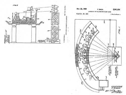
This platform was actually patented by Western Electric.
[url=https://flic.kr/p/oxARTA]
 [/url]
Within the text of the patent is more info about the structure.
Its height is necessary to minimize interference from ground echoes, and the angled rails mounted on the side of the platform (see photos posted above) are radiation guards to screen ground echoes or interference. It had lamp posts for night-time calibration work. The units were actually brought up to the top by a hydraulic lift, which is also visible in the two photos posted above.
In two of the photos on Historic Aerials, you can see the shadow of the tower where the signal-generating device was mounted that sent the beams to the trucks on the platform.
It's hard to believe they tested these things in a neighborhood full of houses. This thing threw out some high energy.
Edited 1 time(s). Last edit at 08/20/2014 08:05PM by WayOutWardell.
This platform was actually patented by Western Electric.
[url=https://flic.kr/p/oxARTA]
Within the text of the patent is more info about the structure.
Its height is necessary to minimize interference from ground echoes, and the angled rails mounted on the side of the platform (see photos posted above) are radiation guards to screen ground echoes or interference. It had lamp posts for night-time calibration work. The units were actually brought up to the top by a hydraulic lift, which is also visible in the two photos posted above.
In two of the photos on Historic Aerials, you can see the shadow of the tower where the signal-generating device was mounted that sent the beams to the trucks on the platform.
It's hard to believe they tested these things in a neighborhood full of houses. This thing threw out some high energy.
Edited 1 time(s). Last edit at 08/20/2014 08:05PM by WayOutWardell.
Re: Radar Calibration Tower
Posted by:
chgojoearchitect
(---.lightspeed.cicril.sbcglobal.net)
Date: November 08, 2014 07:47PM
I grew up at Narragansett & Grand in the 1970s and 1980s. I used to have the book Is There Only One Chicago that someone else referenced where the photo of the tower was in. I can't remember if this was published in the book, or if my father had told me (he trained at Fort Sheridan and then served in the Army during the Korean War), but I believe I remember learning there was a live communication wire that ran from this radar tower all the way to Alaska, and then the White House.
As an interesting side note to the warehouse / factory that was behind this tower. In order for The Home Depot to save money in constructing the current store, they reused the wall from the warehouse that sits on the Normandy side street and then were able to get a permit for "renovation" versus "new construction". A common practice today for builders and architects. If you go look at that side, you'll see the older brick wall mixed in with the new construction.
As an interesting side note to the warehouse / factory that was behind this tower. In order for The Home Depot to save money in constructing the current store, they reused the wall from the warehouse that sits on the Normandy side street and then were able to get a permit for "renovation" versus "new construction". A common practice today for builders and architects. If you go look at that side, you'll see the older brick wall mixed in with the new construction.
Re: Radar Calibration Tower
Posted by:
chgojoearchitect
(---.lightspeed.cicril.sbcglobal.net)
Date: November 08, 2014 08:02PM
I also wanted to mention that the photo in the Tribune article circa 1987, probably shows the back side view of JC Penny from the old Pauli's grocery store that sat on what is now Bricktown Square. It definitely is not the radar station. I remember as a kid Pauli's, Community, and Firestone (the 3 stores on that site) whent vacant and abandoned for years before being torn down and rebuilt as Bricktown Square. Friends and I used to explore the buildings as they were easily accessible to roam around, and that view most certainly must be through the old Pauli's store.
Edited 1 time(s). Last edit at 11/08/2014 08:04PM by chgojoearchitect.
Edited 1 time(s). Last edit at 11/08/2014 08:04PM by chgojoearchitect.


