Radar Calibration Tower
Posted by:
WayOutWardell
(---.dsl.chcgil.sbcglobal.net)
Date: February 24, 2008 06:46PM
Does anyone remember or have a photo of the "abandoned roadway" that used to be on Grand and Oak Park Avenues, just west of Riis Park?
When I was a kid, the lore was that it was a section of unfinished highway that was left behind after budget cuts shut down the project. It was a elevated section of roadway, with a gentle curve that didn't continue to the ground.
As it turns out, it did connect with the ground at one point in time. Trucks with radar equipment were driven up the ramps to the decking, and the units were calibrated when planes from the Douglas plant (now ORD) passed overhead.
Re: Radar Calibration Tower
Posted by:
Jacob
(---.arm-bsr1.chi-arm.il.cable.rcn.com)
Date: February 25, 2008 09:45PM
I've heard something about an abandoned overpass that people used to think was part of the planned Crosstown Expressway. It was said to be near the Brickyard, so this sounds like it could be it. Interesting... anyone know of any photos?
Re: Radar Calibration Tower
Posted by:
WayOutWardell
(63.226.79.---)
Date: February 25, 2008 10:48PM
That's it.
I've only seen one grainy b&W photo in print. I actually went to photograph it a few years ago and when I got there, it had been reduced to a pile of rubble with a Home Depot being built nearby.
It was pretty imposing (scary, actually) when passed at night.
I've only seen one grainy b&W photo in print. I actually went to photograph it a few years ago and when I got there, it had been reduced to a pile of rubble with a Home Depot being built nearby.
It was pretty imposing (scary, actually) when passed at night.
Re: Radar Calibration Tower
Posted by:
Serhii
(---.dsl.chcgil.ameritech.net)
Date: February 25, 2008 11:33PM
I can't find very much on this, but I highly doubt it was expressway-related. The Crosstown was planned to extend south along Cicero from the Edens junction. This is two and a half miles away. It is more likely that it was a building involved in the manufacture of bricks. Then again, I can't find any proof.
Here is an article which mentions children on a large building around Brickyard, and a picture that may be this thing: http://www.forgottenchicago.com/b1.pdf
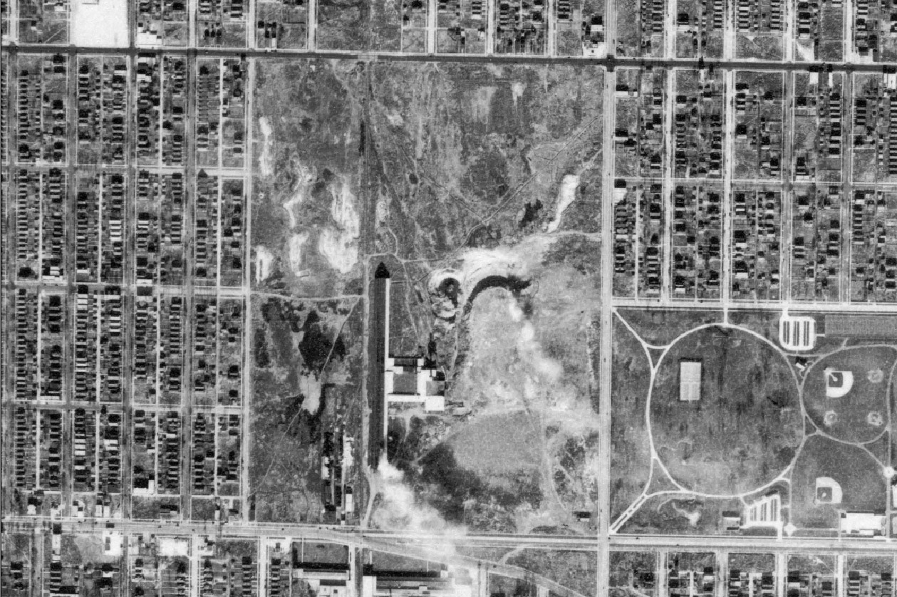
Also, this is an aerial photo of the Brickyard site in 1939:

Here is an article which mentions children on a large building around Brickyard, and a picture that may be this thing: http://www.forgottenchicago.com/b1.pdf
Also, this is an aerial photo of the Brickyard site in 1939:
Re: Radar Calibration Tower
Posted by:
WayOutWardell
(---.dsl.chcgil.sbcglobal.net)
Date: February 26, 2008 02:41AM
There was a book in which was printed the photo I saw...I'll try to dig the title out of the cobwebs of my brain.
The newspaper article photo looks like it, but I'm not sure of the vantage point. The structure was just west of the railroad tracks close to the street.
The newspaper article photo looks like it, but I'm not sure of the vantage point. The structure was just west of the railroad tracks close to the street.
Re: Radar Calibration Tower
Posted by:
paw
(---.hsd1.il.comcast.net)
Date: March 01, 2008 11:30PM
Okay this is only a theory. having looked at the picture and the maps and with some recollection of the old mall. i would have to guess that was the old radar tower in the picture. The tracks would go through the brickyard so there would be debris west of the tracks. it wasnt Oak Park but probably two blocks east. Also, it is interesting to note that looking at the old air photo that Grand Ave was rerouted which is still evident today looking from satellite.
Re: Radar Calibration Tower
Posted by:
tomcat630
(---.hsd1.il.comcast.net)
Date: March 04, 2008 03:42AM
It was not a part of the dead Crosstown Xway at all. Too narrow for one thing. There are newspapaer articles about it, and last I remember seeing it was maybe 1987?
Talking about the old Brickyard site, I remember seeing new Ford Falcons [1968-69?] on the hill there, did a car dealer use it as storage?
They tried to make a ski hill there in like 1969-70, and never happened. Then we know the rest of the story....
Talking about the old Brickyard site, I remember seeing new Ford Falcons [1968-69?] on the hill there, did a car dealer use it as storage?
They tried to make a ski hill there in like 1969-70, and never happened. Then we know the rest of the story....
Re: Radar Calibration Tower
Posted by:
SuperCFL
(---.dsl.chcgil.sbcglobal.net)
Date: March 06, 2008 11:33PM
I think I remember what you're talking about...my father knew all the good secondary streets in the city and sometimes used Oak Park Ave. as a shortcut to Oak Park instead of Harlem. Around Fullerton he pointed out a concrete structure near the Milwaukee Road tracks and said it was an old dumping platoform for coal, like a coal yard would use. Could that be the structure in question? A brickyard would certainly have used lots of coal for the kilns.
Re: Radar Calibration Tower
Posted by:
WayOutWardell
(---.dsl.chcgil.sbcglobal.net)
Date: March 07, 2008 02:41PM
Now that I look at the newspaper article, I don't think that structure in the photo is it. This roadway/platform was much taller than the one in the photo appears to be. I'd guess it was about thirty feet high or so.
Re: Radar Calibration Tower
Posted by:
paw
(---.hsd1.il.comcast.net)
Date: March 07, 2008 03:01PM
Maybe the picture was more directly south of the mall than the Radar tower, but that would be weird having two abandoned structures like that in such close proximity and people only remembering one.
Re: Radar Calibration Tower
Posted by:
jclillig
(---.lew-16.depaul.edu)
Date: March 27, 2008 11:44PM
I remember this thing. It was either just west or just east of Oak Park avenue (I'm pretty sure just east), just north of Grand/Fullerton. It stood in a vacant lot or parking lot.
It wasn't an expressway overpass, but it looked EXACTLY like an expressway overpass, except that it only ran for about half a block. It curved a little bit too.
I remember adults explaining what it was to me when I was a kid, but I never retained what it was--it looked JUST like an expressway.
I agree that it is not the same thing pictured in that newspaper article.
Re: Radar Calibration Tower
Posted by:
tseals
(---.dsl.chcgil.ameritech.net)
Date: April 11, 2008 11:39PM
I also remember it as akid. My old man had told me that it was used to calabrate radar> I wasn't sure what kind of radar.
Re: Radar Calibration Tower
Posted by:
mark
(---.illinois.net)
Date: May 06, 2008 05:24PM
The first poster was right. Geoffrey Baer explained it on Chicago Tonight last week.
Re: Radar Calibration Tower
Posted by:
tomcat630
(---.hsd1.il.comcast.net)
Date: May 24, 2008 08:12PM
If you go to the Historic Aerials website http://historicaerials.com/
in the links section, you can see different views of the Brickyard area. The Calibration Tower or "bridge to no where" can be seen in 1950's to 70's views.
The Aerials site is great, like a real time machine! Can see at least one view per decade of the whole region, going back to 1938.
Edited 1 time(s). Last edit at 05/24/2008 09:42PM by tomcat630.
Re: Radar Calibration Tower
Posted by:
telefrank
(---.dsl.chcgil.ameritech.net)
Date: May 30, 2008 06:21PM
It was built by or for Motorola. Once upon a time a proud Chicago company.
Re: Radar Calibration Tower
Posted by:
jjcairo
(---.proxy.aol.com)
Date: June 02, 2008 08:43PM
i remember that it was called thunder moutain! before that it was the carry brick yard. they used to exavate mud for the bricks untill they hit a under ground spring and it filled with water in the mid 50's. that's where chicago street paver bricks and the red bricks were made. the compeney went bellie up and it was used for a land fill by the city of chicago. jim moran the courtsy man from courtsy ford on grand ave used to park his new cars on top of it after it was filled in. right in back of the com ed switch yard. the long baking ovens were still there up untill the early 70's they ran north and south from grand to deversy ave, and west of narragansett. pardon my spelling! i also remember that factory that built radar equipment. and it did have a over pass that went no where. every time you would walk past the building that had green frosted glass in the windows so you could not see inside and high barbed wire fences around it. there was always a loud high voltage hum coming from inside.
Re: Radar Calibration Tower; Brickyard Hill
Posted by:
tomcat630
(---.hsd1.il.comcast.net)
Date: June 03, 2008 11:27PM
Thanks for clearing up an old memory of new Ford Falcons parked on top of "Brickyard Hill" in late 60's. My older brother said there was an actual dealer up there, but I figured out later it was a car storage lot.
One failed plan for the 'Hill' was a ski slope. Signs were put up, but it was never built. I remember the sign for "ski slope coming soon" stuck around til at least 1970.
One failed plan for the 'Hill' was a ski slope. Signs were put up, but it was never built. I remember the sign for "ski slope coming soon" stuck around til at least 1970.
Re: brick yard hill
Posted by:
jjcairo
(---.proxy.aol.com)
Date: June 17, 2008 10:32PM
thunder moutain was open for one winter season and then it closed. i think in 68 or 69? if my memory serves me?
Re: Radar Calibration Tower
Posted by:
Anonymous User
(---.coxfiber.net)
Date: January 21, 2009 03:55PM
Thunder Mountain was indeed built. I lived about 4 blocks away. When I was a kid, I could remember seeing the lights on the slope from my yard. There was also a chalet built for drinking and dining. Twin Buick would use the abandonded lot for storing cars. We would "climb" the side of the mountain by pulling ourselves up using the old ski cables that had fallen and been buried in the side of the hill. The "mountain" was built up by the city of Chicago using the land to dump the rubble from the construction of the Kennedy Expressway. The curved bridge right near there on Fullerton and Nordica was used during WWII to adjust radar on planes. It sat unused for years. It was really creepy looking and quite intimidating. Right behind the bridge was the Carey Brick Company. As kids in the mid to late 70's we would go snooping around in the abandoned offices for the brick company. What was really creepy is that it looked like people left work one day and never came back. There were files and papers and furniture all left behind. It was like stepping back in time. Of course, the security guard wandering around the area was not afraid to pop you with a pepper gun. Most of the excitement of being where you shouldn't be was trying to avoid the guard.
Re: Radar Calibration Tower
Posted by:
Philomena
(---.frstil.dsl-w.verizon.net)
Date: January 22, 2009 10:14AM
In the 1960s it was called "the highway with no beginning & no end." It was unique & we would have great discussions w/anyone not familiar with it.
In the 1970s, on the West of it, Hall Printing Company used an old factory for paperback books.
Would someone please advise how to use the aerial sight to look at that road.
In the 1970s, on the West of it, Hall Printing Company used an old factory for paperback books.
Would someone please advise how to use the aerial sight to look at that road.


